|
Talk: Maps and Charts of Singapore from the Archives of Continental Europe- a talk by Dr Peter Borschberg Posted By author On August 15, 2009 @ 3:05 am In Past Activities,Talks | No Comments |
venue: The Pod, Level 16 The National Library, 100 Victoria Street
date / time: Saturday, 15 Aug 2009; 2.00–4.00pm
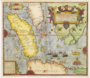
Studies of the historical cartography of Singapore and Malaya have commonly been based on British and Japanese maps and charts even though the area has been a vital international maritime crossroads centuries prior to the founding of the island by Raffles in 1819. In his research on the involvement of continental European nations in Southeast Asia between the 16th and 19th centuries, Peter Borschberg has encountered rich archives of maps
and other navigational illustrations on what is now Singapore from libraries and archival centres across continental Europe. Borschberg will discuss his findings and share his collection painstakingly accumulated over the past decade.
Aside from their graphic and colourful designs and accounts, these illustrations are critical in revealing Singapore’s global significance in the pre-Raffles era.
Associate Professor Peter Borschberg BA (Hons)(Kent); PhD (Cambridge), is senior lecturer in the
Department of History at the National University of Singapore. His research interests covers that of Southeast
Asia in the early modern period as well as legal history. His main publications include: Remapping the Straits
of Singapore? New Insights from Old Sources (in press); The European Musk Trade with Asia in the Early
Modern Period (Oriente, 2003); ‘The Seizure of the Santo Antonio at Patani: VOC Freebooting, the Estado
da India and Peninsular Politics?’ (Journal of the Siam Society, 2003); Portuguese, Spanish and Dutch
Plans to Construct a Fort in the Straits of Singapore, ca. 1584-1624? (Archipel, 2003); A Luso-Dutch Naval
Confrontation in the Johor River Delta 1603 (Zeitschrift der Deutschen Morgenlaendischen Gesellschaft,
2003); ‘The Seizure of the Sta. Catarina Revisited. The Portuguese Empire in Asia, VOC Politics and the
Origins of the Dutch-Johor Alliance’ (1602 ?c.1616)? (Journal of Southeast Asian Studies, 2002); and Iberians
in the Singapore-Melaka Area (16th to 18th Century).
Article printed from Singapore Heritage Society: https://www.singaporeheritage.org
URL to article: https://www.singaporeheritage.org/?p=216
URLs in this post:
[1] Image: http://www.singaporeheritage.org/wp-content/uploads/2009/08/Peter-Borschberg-Talk.jpg
[2] Flyer: Maps and Charts of Singapore from the Archives of Continental Europe- a talk by Dr Peter Borschberg: http://www.singaporeheritage.org/wp-content/uploads/2010/09/Peter-Borschberg-Talk-Lo-Res.pdf
Click here to print.
